Briefing:
- Continuing to monitor rain tomorrow; heavy at times
- Winter-like nor’easter
- Flash flood potential
- Comfortable this morning, humidity will rise later on
Discussion
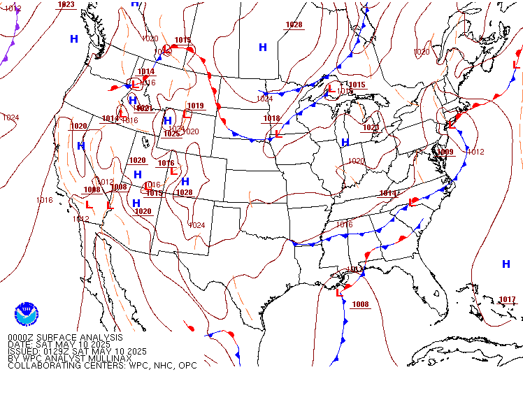
Current surface map shows cold front in the Plains (two of them, but part of the same overall system) and the southern low pressure area. These two areas will interact more and more during the day today and tomorrow they will converge in the Mid-Atlantic and Northeast.

With the southern low, it will tap both Gulf and Atlantic feeds, increasing available moisture. That will be part of the reason why the precip rates will be heavy at times. We have a converging of cold air meeting Gulf and Atlantic moisture feeds.
Latest water vapor with my caveman illustrations showing that idea of a double cold front and low pressure down south.

Pattern is typical of a nor’east during the winter. We have deep troughing in the Central U.S and storm coming up out of the Gulf.
Visible satellite shows clouds moving in from the south.

Model Discussion
The NAM at 850mb shows shortwave trough rounding the base and low pressure area to the south

Later tonight into tomorrow things begin to converge and the main troughing envelopes the southern low

Meanwhile our surface charts, with image below from the NAM, reveals possibilities in storm track and where the heaviest axis of precip falls.

NAM wants to bring the southern low over E. Va

And your heavy rain is to the north of the low and between the low pressure area coming in from the Mid-West where the cold/warm clash the most in the upper levels of the atmosphere.

NAM has shifted the heaviest axis to the west a little associated with best clashing of airmasses. But there is also another batch of heavy precip to the north/northeast of the coastal low ahead of the warm front.
Note, the image I am using for precip/radar is the 3km NAM, which actually slides the coastal low just to over Atlantic City whereas the 12km NAM I’ve used in the other above images places the low a bit more to the west. The idea remains the same as yesterday, depending on how the low tracks will determine where the heavy rain falls.
Accumulated rain through Thursday 2 PM

Biggest impact is the possibility of flash flooding as many areas will see 0.5″-1″ of rain in a short period of time.
But for now all we can do is monitor the radar, see where the low pressure is trying to move in the pressure charts, and see what happens.
Temperature Today
Low to mid-70s for most of the area

Air Quality:

Current air quality is mostly clear!
The AQI is based on a scale of 0-500, with 0 being no issues and 500 being very hazardous to everyone and an emergency condition overall. Today we will be between 0 and 50, so generally fine for all people.
More specific air quality information can be found at airnow.gov

